yesteryears' playground
the playground of ours was less colourful and simpler in design. it would usually comprise a slide, two see-saws and two or three swings. in some places, there would be a monkey-bar.
Wednesday, December 30, 2009
Sunday, February 15, 2009
homing.....to jurong bird park


i was at one side of the pang sua canal, across from warren country club, when i saw this flock of egrets resting on the railings. at around 5.30 p.m. another flock came winging towards them. as if as one, all of them took off and joined the flying flock. it seemed like they were collecting everyone to fly back to their nesting place at jurong.
most of these egrets nest at jurong birdpark but spread out all over the island during the day to find food.
the little egret is the smallest and most common egret in singapore. singapore receives a good concentration of these migrants during the winter (september-may).
i come across the little egrets all over the island, especially the western part of it. they can be found on open fields, near waterways, especially canals, and at the edge of ponds and reservoirs. they can also be found along the coastal areas.
little egrets are the liveliest hunters among herons and egrets, with a wide variety of techniques. they may patiently stalk prey in shallow waters. or stand on one leg and stir the mud with the other to scare up prey. or better yet, stand on one leg and wave the other bright yellow foot over the water surface to lure aquatic prey into range.
they eats fish, crustaceans and insects.
Friday, February 13, 2009
prunus-petai trail @ macritchie


the 3km nature walk along the prunus-petai trail is a good introduction for any newcomer to walking/hiking at our nature reserves. the prunus and the petai trails are board walks.
the petai trail is actually a continuation of the prunus. you can finish your walk by taking the gravel track of the macritchie nature trail. when you come to the end of the petai trail, turn right onto the macritchie trail. taking the left will lead you to the jelutong trail and the tree-top walk.
the 3km walk is correctly graded an easy walk/hike, which can be completed within the hour. at the start of the board walk, you can feed the hundreds of tinfoil barbs in the reservoir. (they have now put up notices to advise people against feeding the fish.) there are so many of them that the crumbs disappear the moment they hit the water.
the tinfoil barb is a fish that is often available in pet shops and sold to the beginning aquarist but it is not the best choice for those beginning in the freshwater hobby. the tinfoil barb requires a very large tank, at least 284 litres because of its potential adult size of 32 cm.
they like to have lots of space for swimming and they are indeed fast swimmers. they also like to jump out of tanks that don't have tight fitting hoods. tin foil barbs will accept most fish food, including flakes, pellets, frozen and freeze-dried foods. they will also go after your live plants and any smaller fish if given the opportunity.
today, i came across a troop of monkeys playing in the shallows of the reservoir. some were on the board walk but a number of them went to play in the water. like playful children, they were having a splashing time in the water.
all along the two trails, there are information sign boards telling you more about the flora and fauna that you will see along the way.
whenever i go for my walk, i do not park my car in the macritchie car park as it is a hassle when you want to exit macritchie and get onto leonie road. i usually park my car along one of the roads in the westlake private housing estate or along the stretch of road leading to the little sisters of the poor.
Wednesday, February 11, 2009
scenes @ kranji


kranji is one of the few places you can escape to when you need peace and quiet. scenic spots are aplenty although there are also eye-sores like the flotsam at the water edge near the kranji park.
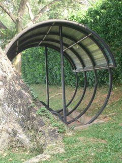
there are also some unusual features like the bus-stop kind of shelter in the middle of the fishing ground and the row of transmitting towers which can be seen in one of the pictures.
kranji is quite similar to lower seletar in that the dam/road separates the reservoir from the sea. so, on one side you have fresh reservoir water and on the other side you have salty sea water.
this nine-hectare park has two designated fishing areas where enthusiasts can cast their lines while watching the colourful king-fishers catch their prey.
constructed in 1979, the park also has a children's playground.
the transmitting towers are used by bbc far eastern service and by singapore's media corp. not many people know of the location of the station at turut track.
among the flotsam that was washed up by the tide and waves were some plastic flower pots, lots of mineral water bottles, containers for packing food and part of a road barrier.
i was curious to know why there was such a structure - the shelter - at the park. the park supervisor explained to me that it was meant for anglers and other park users to seek protection from the rain. i find that it is a nice place to rest or even take an afternoon nap as it is cool and breezy.
Tuesday, February 10, 2009
upper boon keng/kallang bahru park connector \


the more parks i visit, the more appreciative i am of the work being done by national park board to make singapore a more liveable place for us. it is a pity that not as many singaporeans and other residents are taking advantage of the excellent facilities and amenities provided by national park board.
the upper boon keng and kallang bahru park seems under utilised and under visited in comparison with parks like bukit batok nature park and macritchie reservoir park. at eight in the morning, you find the odd joggers and isolated groups doing calisthenics type of exercises.
then there are residents who use the jogging or cycling track as a short cut to the bus stop or their work place. much unlike at bukit batok where you can hardly find a parking space at the car park - which has around 124 parking lots.
there are a few nice bridges here that span the river. along a certain stretch there are barbeque pits. rounding the bend, i came across this attractive chinese temple. it is called chwee kang beo (in hokkien) or shui jiang miao (in mandarin).
the water in the river is so clean that, on a warm day, you will be tempted to have a dip in it if bathing facilities are made available at the park. it is also teeming with fish. as you walk along the path beside the river, you will come across schools of fish. i saw a large fish - about half a metre long - swimming in the middle of the river. even the cat and the birds seem to know that there is food in the river.
Monday, February 9, 2009
tulous - hakka's earth buildings


my friend victor samuel and his wife helen, both retired, went with their church friend jason, who retired when he was in his forties, to yongding county in southern china. they made the trip together with 16 members of the s'pore adventurers' club.
they flew tiger airways to quangzhou. from there, they took the night train to yongding. helen complained that she could not sleep a wink during the ride.
they flew tiger airways to quangzhou. from there, they took the night train to yongding. helen complained that she could not sleep a wink during the ride.
i was at victor's place for dinner on friday. after dinner, he showed me all the 600 pictures that he had taken with his digital camera.
a lot of the pictures showed the tulous which the americans had mistakenly thought were missile launching silos.
a lot of the pictures showed the tulous which the americans had mistakenly thought were missile launching silos.
each tulou will usually house around 20 families with about 100 people in total. the houses are built around a main courtyard to allow in light and air, and to house livestock. they have wells and complex drainage systems so they can be completely self-sufficient for long periods of time.
the walls are about a metre thick and the doors are bolted. the ground floor has slits for rifles, the second floor is for storing grains or rice, and the third and fourth floors are inhabited. they are effectively fortified villages.
the walls are about a metre thick and the doors are bolted. the ground floor has slits for rifles, the second floor is for storing grains or rice, and the third and fourth floors are inhabited. they are effectively fortified villages.
from his pictures, i could see that every tulou has a stream or river flowing in front of it. it seems that the hakka people believe water will bring luck to them, especially if the water is flowing in front of the house.not all tulous are round.
in fact, there are more square tulous than round ones in china. most young people have moved out of their traditional homes. those who still occupy the tulous are the elderly people and young children
in fact, there are more square tulous than round ones in china. most young people have moved out of their traditional homes. those who still occupy the tulous are the elderly people and young children
Sunday, February 8, 2009
reflection in kallang and lake matheson
(in new zealand)


this reflection of buildings in the kallang river reminds me of our first trip to new zealand. we had been so excited about the view to be had at the mirror lake that we did not mind the forty minutes walk from the road to the viewing platform.
however, we were thoroughly disappointed because all we saw was the dull water of the lake sans the refections of the southern alps. the conditions that particular day were not suitable for any picture perfect image in the water.
about 6km from the fox village on the gillispies beach road, lake matheson is a tiny lake well protected from the wind. this means the waters are often incredibly still. not everyone who goes there get to witness the spectacular sight.
it seems the best chances to see the reflections is in the morning. at lake matheson, nature has combined exactly the right ingredients to create truly stunning reflections of new zealand's highest peaks - aoraki (mount cook) and mount tasman. the waters of lake matheson are dark brown, so on a calm day they create the ideal reflective surface.
the colour is caused by natural leaching of organic matter from the surrounding native forest floor. by a happy coincidence, the mountains to the east are perfectly positioned to reflect in the lake.
i captured this reflection of the buildings at bendemeer in the kallang river when i went for my morning walk at about 7.15 a.m. today.
Subscribe to:
Posts (Atom)